The Best Backcountry Hikes in HVNP
Underrated Backcountry Hikes
Volcanoes National Park, located in Hawaii, offers an array of hiking trails that cater to various fitness and experience levels. These trails allow visitors to explore the park's beautiful landscapes, which are dominated by two active volcanoes, Kilauea and Mauna Loa. We have pulled together some of our favorite hikes on The Big Island of Hawaii, and specifically hikes in The Volcanoes National Park. We can promise you, that you can't go wrong with any of these trails.
And voila! We present to you our favorite hikes on The Big Island.

Things to know about Volcanoes National Park
Located only 3 miles from the Lotus, the park is stunning and varied and has many trails for all technical levels.
Things to know:
- A park entry fee applies (it's worth it!)
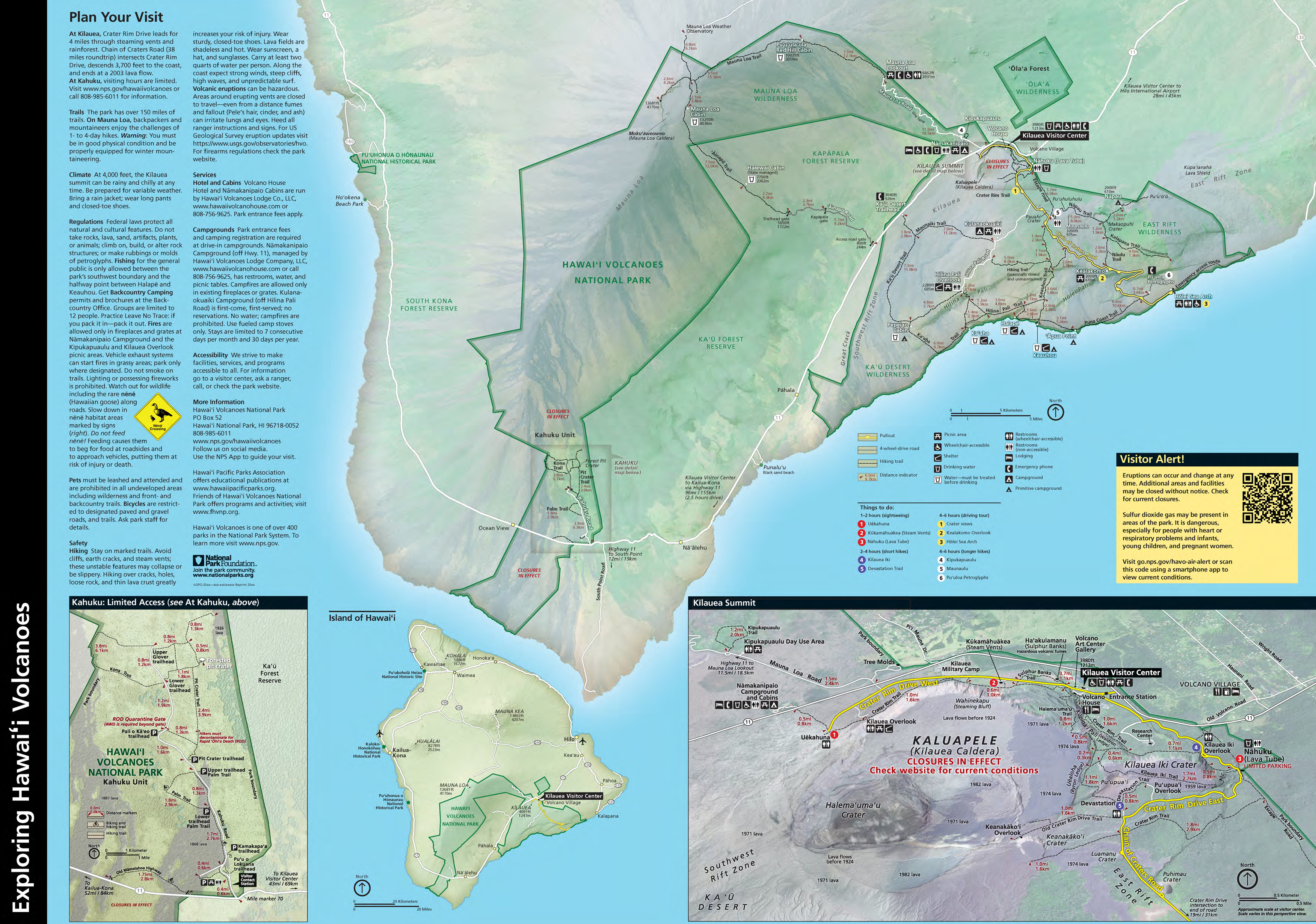
- A park map and table of trails are available online.
- Click here to discover the family-friendly trail map
- Google Maps Link

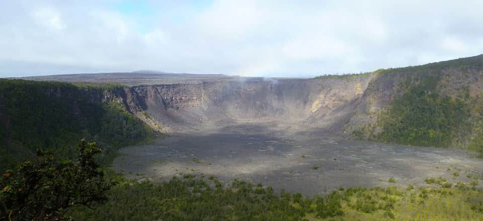
Kīlauea Iki Trail:
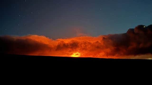
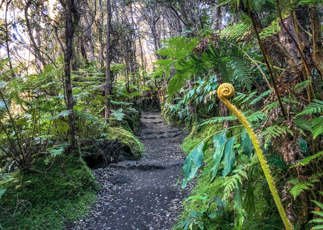
This 4-mile loop trail descends 400 feet through a lush rainforest, into the Kīlauea Iki Crater, and across the still-steaming crater floor, giving hikers a firsthand experience of the volcano's raw power.
Difficulty: Moderate to challenging - Steep and rocky, decent & Ascent 400 feet
Parking: Extremely limited parking at Kilauea Iki Overlook. During Peak hours there may be no parking available.
Distance:
From Kilauea Iki Overlook: 3.3 mile (5.3 km) loop. Plan for 2-3 hours
From Kilauea Visitor Center: 5.3 miles (8.5 km) round-trip "cherry stem" and loop. Plan for 3 to 4 hours
From Devastation Trailhead: 6.0 mi (9.7 km) round-trip. Plan for 4 to 5 hours. Parking at Devastation Trailhead allows for a more scenic experience.
Preparation: Bring water, food, hat, sunscreen, and rain gear. Be prepared for hot, dry, wet, windy weather conditions and steep and rocky terrain.
Safety: Hiking on flow fields can be hazardous due to deep earth cracks, uneven and unstable terrain and razor-sharp lava.
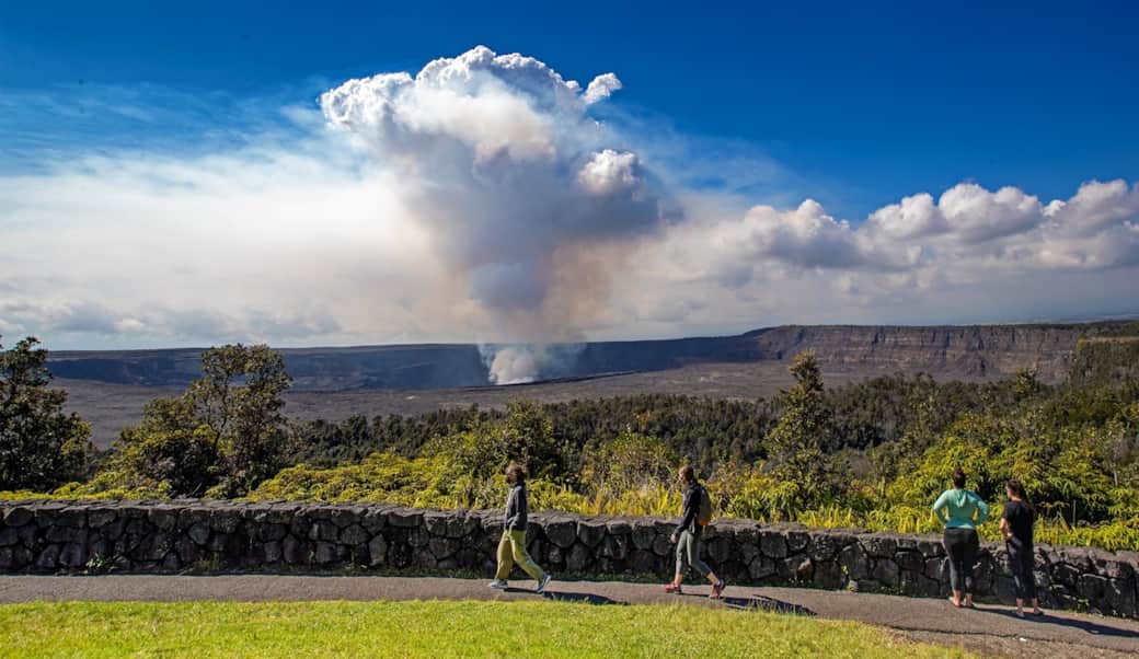
Halema'uma'u Trail:
This 3.2 mile trail descends 425 feet into the Kīlauea Caldera, passes through a rainforest that is slowly being overtaken by the volcano's frequent eruptions, and then extends across the astonishingly vast, barren plain of Halema'uma'u Crater.
- Difficulty: Moderate
- Distance and hiking time:
- 0.8 miles (1.3 km) one-way from Crater Rim Trail to the floor of Kaluapele (Kīlauea caldera)
- 1.3 miles (2.1 km) one-way from Crater Rim Trail to the top of Uēaloha (Byron Ledge), allowing for longer hikes to Kīlauea Iki and Nāhuku (Thurston Lava Tube)
- Trail begins: Behind the Volcano House off Crater Rim Trail.
- Bring: Water, food, hat, sun protection and rain gear. Be prepared for hot, dry, wet, and windy weather conditions.
Currently Restricted due to Active Lava!
Maunaulu / Pu'uhuluhulu:
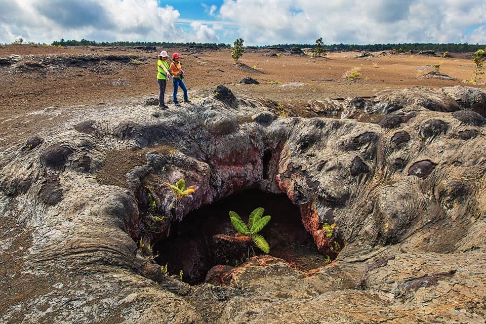
Maunaulu is a prominent lava shield formed during the 1969-1974 eruption. This significant geological event, centered just downhill from Puʻuhuluhulu cinder cone, dramatically surrounded most of the cinder cone over five years.
Puʻuhuluhulu cinder cone is accessible via a short day hike beginning at the Maunaulu parking lot. In reference to its vegetation-covered slopes, Puʻuhuluhulu means "hairy hill" in Hawaiian and stands out in stark contrast to the adjacent lava flows of Maunaulu.
- Difficulty: Moderate - Most of the route is easy, but includes a 1/4 mile steep climb up Pu‘uhuluhulu cone.
- Distance and hiking time: 2.5 miles (4.0km) roundtrip, Approximately 2.0 - 3.0 hours.
- Trail Begins: Approximately 100 yards (91.4m) from the Maunaulu parking area. Ahu (stacked rocks) mark the trail across the lava flows. Please do not disturb them or build new ones. Stay on the trail.
- Bring water, food, hat, sun protection and rain gear.
- Safety: Hiking on flow fields can be hazardous due to deep earth cracks, uneven and unstable terrain, and razor-sharp lava.
Protect delicate lava formations. Surface patterns and lava trees are fragile. Reduce your impact. Please do not touch these formations.
Crater Rim Trail:
This 11.3-mile trail encircles the Kīlauea summit caldera, passes through desert landscapes and luxuriant forests, and brings hikers to breathtaking overlooks that peer straight into the heart of the active volcano.
- Difficulty: Easy
- Distance is variable. Trail stretches from Uēkahuna on the north side of the caldera to just past Keanakākoʻi Crater on the south side. The trail includes Kūpinaʻi Pali (Waldron Ledge)
- Hikers may access the trail from several locations along Crater Rim Drive, including Uēkahuna, Kīlauea Overlook, Steam Vents, and Volcano House.
- Bring water and food. Be prepared for hot, dry, wet, and windy weather. Scorching sun, biting winds and pelting rain can occur in the same hour.
- STAY ON MARKED TRAILS
- Cliffs, earthcracks, and steam vents have unstable and slippery edges. Keep well back for your safety.
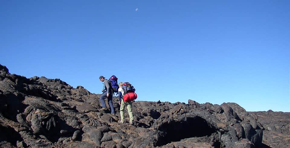
Mauna Loa Summit Trail:
This is one of the most challenging treks on the island, climbing 7,000 feet in 19.5 miles from the trailhead at the Mauna Loa Lookout to the volcano's summit.
Please view the National Park Website for full details on this trail:
Hazards
Weather Hazards
Be prepared for severe winter conditions, including blizzards, high winds, and whiteouts. Snow or driving rain are possible at any time of year. High altitude storms can occur without warning. Temperatures are below freezing at night all year round.
Currently Restricted due to Active Lava!
Napau Crater Trail:
This 14-mile round trip trail descends from the Mauna Ulu parking lot to the Napau Crater through varying terrain, boasting views of numerous eruptions sites, Mauna Ulu, Pu'u Oo, and even, on clear days, the coastline.
Please view the National Park Website for full details on this trail:
Hazards
Trail Conditions
Hiking over rocky terrain is strenuous. Hiking boots provide the best traction and protection when hiking on lava. Long pants afford some protection if one should fall on the sharp, glassy lava. The Nāpau and Nāulu trails traverse over rough, unstable ʻaʻā and pāhoehoe lava. There may be only a 200' elevation change on the Nāpau Trail and a 500' elevation change on the Nāulu Trail. Allow 1/2 hour per mile when hiking on these mid-elevation trails. Add additional time for scenic stops and breaks.
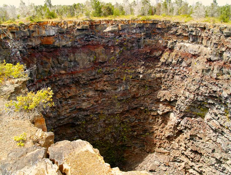
Devil's Throat: This is a short and easy 1.2-mile hike that leads hikers to one of the park's most bizarre and terrifying natural wonders: a yawning, 165-foot deep pit crater that formed during a sudden collapse of the ground.
That’s because it’s on the decidedly primitive side of things when it comes to park attractions. It’s a very short, very easy stroll off-pavement, but not signed or edged by guardrails. The dirt path ends at a yawning, steep-walled, 165-foot-deep cavity that sort of sneaks up on you.
You’ll find the pull-off for the Devil’s Throat along the Chain of Craters Road. Coming from the Kilauea Caldera area, it’s on the right side just past the junction with the Hilina Pali Road. Across the Chain of Craters pavement, you’ll see a dirt path heading eastward. It’s a quick mosey to reach the pit crater.
Because it isn’t fenced-off or heavily signed, you need to proceed a little gingerly on the access path. Needless to say, you don’t want to accidentally stumble off the edge and fall 165 feet down. This is not a destination to tackle after-hours, or (if you can avoid it) in misty or rainy conditions. If it’s windy, be especially conservative. A stiff gust could potentially blow you down into the pit if you’re too close to the edge.
Insider Tip:
-As far as parking goes, feel free to park on the side of Chain of Craters Road in a small inlet just past Hilina Pali Road.
-The Devil’s Throat isn’t necessarily a great attraction for young kids. If you do visit with young children, keep them close as you walk the dirt path. Don’t let them run ahead!
photo credit: Donald B. Macgowan
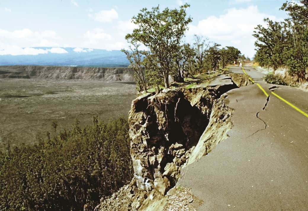
Kupina'i Pali aka Waldron Ledge aka Earthquake trail: This short 0.8-mile loop features interpretive signs that explain the geological forces at work beneath your feet.
At one point in time, this stretch of trail was part of Crater Rim Drive, the road that encircled the summit caldera. However, on November 16th, 1983, a magnitude 6.7 earthquake struck the island, decimating parts of the road. Large chunks collapsed and deep cracks developed, rendering it impassable. As part of repairs from the seismic event, the road was re-routed to its current path and the portions left behind were converted to the trail you see today. Look for the painted road lines on the trail, a reminder of its history. Locally, this area may still sometimes be referred to as "Earthquake Trail."
- Difficulty: Easy - wheelchair accessible.
- Distance & hiking time: About one mile (1.6 km) round-trip to the overlook, approximately 45 minutes - 1 hour.
- Trail begins: Across the street from Kīlauea Visitor Center, to the left of the Volcano House, and down the service road to the rock wall on the left.
- Stroller friendly - Trail is over a paved road surface.

Join us at Lotus on Jade for an unforgettable retreat in the heart of nature.
We hope you found a new hike to try in our list of favorite hikes at the Volcanoes National Park. Our cozy rooms are full of comforts and a serene ambiance that is the perfect way to end a day of hiking exploration. We invite you to book your stay now and experience our rooms' ultimate tranquility and style. We look forward to hosting you!
U'ilani and JD